

Forecast hour +2
Thu 1 Oct, 01:05
Generated 23:32Weather detail
- Forecast assessment
- Upper wind range remains below 18 kt and gusts remain below 25 kt.
- Wind change
- Steady (0.0 kt)
- Direction-change risk
- 0%
- Weather regime
- Showery / unstable
- Provider agreement
- Strong agreementSource wind spread 0.0 kt; direction spread 0°.
- Selected sources
- Local 85%Persistence 15%
Gust probability
18+ kt85%
20+ kt62%
25+ kt16%
30+ kt2%
TBSC course selection
Short course195° magnetic
Why this course set?Short selected because the forecast mean is 11.3 kt and gust 20.9 kt, outside the Force 3-4 band; the card uses Short for Force 1-2 or Force 5 conditions.The 192 degree true forecast converts to approximately 193 degrees magnetic and uses the nearest 15 degree matrix column: 195 degrees.
| Fleet | Course |
|---|---|
| Oppy 2 | 1R reverse |
| Optimist | 3R reverse |
| Feva | 10R reverse |
| Slow Misc | 10R reverse |
| Myth | 10R reverse |
| Misc | 18R reverse |
| 1/2 Rater | 18R reverse |
| Start | Red reverse |
Wind-based selection; shorten for poor visibility, rough sea or other race-management concerns.
Trearddur Bay Sailing Club
Sailing area
Thu 1 Oct, 01:05 · Wind SSW 192 deg T at 11.3 kt, gust 20.9 kt · Short course, 195 deg magnetic
Course overlay ready
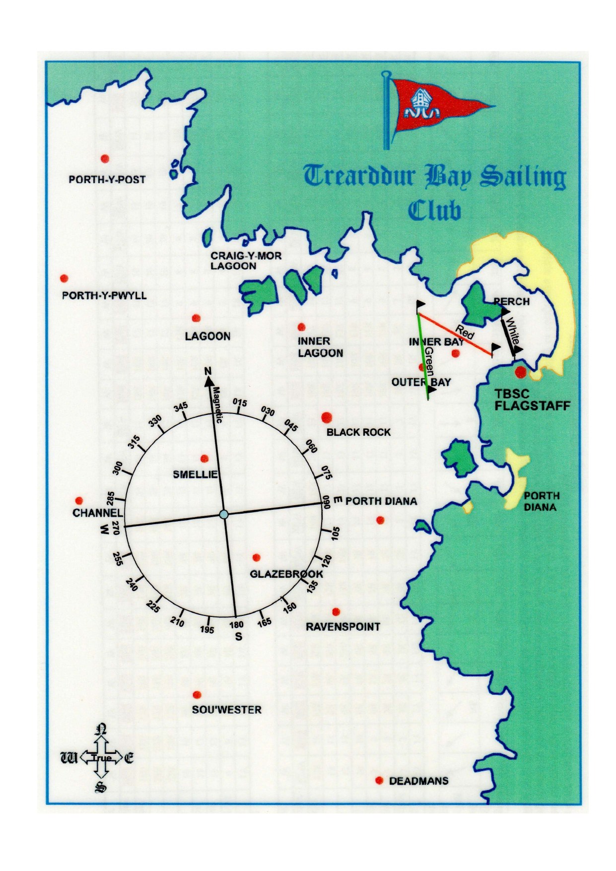
Course 1ROppy 2Route diagram referenced as page 27 but not included in the supplied scan
Why: The 2026 selector assigns Course 1R to Oppy 2 for this course length and magnetic-bearing column. Its route refers to page 27, which was not included in the supplied scan.
Course 3ROptimist4 rounds · Outer Bay · start Red
Why: The Short matrix at 195 degrees magnetic assigns Course 3R to Optimist. The R suffix selects the published reverse mark sequence. The route starts at the midpoint of the Red line, uses Outer Bay as its Bay Mark and finishes at the midpoint of the white line.
Course 10RFeva2 rounds · Green Bay · start Red
Why: The Short matrix at 195 degrees magnetic assigns Course 10R to Feva. The R suffix selects the published reverse mark sequence. The route starts at the midpoint of the Red line, uses Green Bay as its Bay Mark and finishes at the midpoint of the white line.
Course 10RSlow Misc, Myth2 rounds · Outer Bay · start Red
Why: The Short matrix at 195 degrees magnetic assigns Course 10R to Slow Misc, Myth. The R suffix selects the published reverse mark sequence. The route starts at the midpoint of the Red line, uses Outer Bay as its Bay Mark and finishes at the midpoint of the white line.
Course 18RMisc1.5 rounds · Green Bay · start Red
Why: The Short matrix at 195 degrees magnetic assigns Course 18R to Misc. The R suffix selects the published reverse mark sequence. The route starts at the midpoint of the Red line, uses Green Bay as its Bay Mark and finishes at the midpoint of the white line.
Course 18R1/2 Rater1.5 rounds · Inner Bay · start Red
Why: The Short matrix at 195 degrees magnetic assigns Course 18R to 1/2 Rater. The R suffix selects the published reverse mark sequence. The route starts at the midpoint of the Red line, uses Inner Bay as its Bay Mark and finishes at the midpoint of the white line.
The blue wind arrow points downwind; its label states the direction the wind comes from. Each coloured course begins at the midpoint of its selected Red or G/W start line and ends at the midpoint of the white finish line. Coloured arrowheads show the order of travel. Lines show the mark sequence once; follow the number of rounds in the key. Published port/starboard rounding instructions remain authoritative.
Forecast sources
| Source | Wind | Gust | Direction |
|---|---|---|---|
| Local | 11.3 kt | 20.9 kt | SSW 192° |
| Persistence | 11.3 kt | 20.9 kt | SSW 192° |
Guidance only. The race officer's decision, current observations, sea state, visibility, tide, official warnings and local safety procedures take precedence over this experimental forecast.